Thursday, June 30, 2011

A Little Bit of Geography

South America - Physical Map (Cartography)

Dr. Edmar Bernardes DaSilva (Masters in Geography and Doctor of Geography Education)

First, for the purpose of this article the term geography must be defined. Geography is an integrative discipline that brings together the physical and human dimensions of the world in the study of people, places, and environments (Geography for Life, National Geographic Society, 1994 in Mansfield, 2005).
Geography is one of the oldest of the sciences and scholarly disciplines. ­Like astronomy, geography is concerned with the content of space. ­It may be said that geography has a shared common origin with astronomy.
The peak of Geography’s relative importance as a discipline among sciences came in the period of the great explorations (from the 15th century into the 19th century: Vasco da Gama…).
Early Greeks geographers who first gave structure to geography. Eratosthenes (276 BC - 194 BC) the father of classical geography, was the first to coin the word geography. He paved the way in the study of the earth . ­He was born in the Greek colony of Cyrene in Libya. He wrote a book describing the ekumene, the inhabited earth, in which he accepted both the major divisions of Europe, Asia, Libya, and the five zones: a Torrid Zone, two Temperate Zone, and two Frigid Zones. ­Started his education in Cyrene and later in Athens. ­Eratosthenes died at the age of 80. ­Is to this day one of the greatest geographers of all ages.

Modern geography had its origin in the surge of scholarly inquiry that, started in the 17th century Germany: important place for the development of modern geography. Germans are in reality the fathers of modern geography, and the greatest German geographer was Alexander von Humboldt (1769-1859). Regarded as the father of modern geography. Von Humboldt studies, travels and scientific wisdom transformed natural science in the nineteenth century.

Why learn geography? What can I do with geography?

   Ouro Preto Brazil - A Cultural Landscape (Urban Geography)

Geography has useful value in the modern globalized world. As the linkages of the world accelerates the realistic need for geographic knowledge (geographical education) becomes more serious. Think about a doctor who treats diseases without understanding the geographical environment in which the diseases flourish and proliferate, or a manufacturer who is ignorant of world markets and resources, or a postal worker anywhere who cannot differentiate Austria from Australia. With a strong understand of geography, people in general are better equipped to solve issues at not only at the local level but also at the regional, national and global levels.

Fields of Geography

Earth Systems Science (Physical Geography)Focuses on research and education dealing with Earth’s dynamic processes, materials and physical properties (weather, climate, geology, landforms and landscapes, soils and bioregions).

Human-Environment Systems Science (Human Geography)Focuses on the measurement, analysis and modeling of human and environmental systems
and their interactions at various spatial and temporal scales.

                         Rice Fields in India (Economic Geography)

Subfields of Human Geography:
Cultural Geography
Economic Geography
Urban Geography
Political Geography
Environmental Geography

Tourism Geography
Population Geography...

   Population Pyramids of the USA/2010 (Population Geography)

Geo-Information Science (Cartography)
This area emphasizes analytical techniques suited to the understanding
and modeling of the Earth and human phenomena.


The five Fundamental Themes of geography are summarized by a joint committee of the National Council of Geographic Education and the Association of American Geographers:

LocationThe meaning of relative and absolute position on the earth’s surface.
Lines of Latitude and Longitude (Source: Online Geography Resources)

                       Mongolia (A Place on Earth)

Place:The distinctive and distinguishing physical and human characteristics of locales.

Relationships within places: The development and consequences of human-environment relationships.

MovementPatterns and change in human spatial interaction on the earth.

RegionsHow they form and change.
                              World Regions

Copyright © All right reserved/July-2007

Friday, June 17, 2011

Physical Geography


Dr. Edmar Bernardes DaSilva (Masters in Geography and Doctor of Geography Education)

Physical geography is the study of the natural landscapes on the face of the Earth, better defined as the study of the conditions of the natural landscapes. Physical geography involves Water Resources (water resources on land: rivers, lakes...), Palaeogeography (studies of ancient geologic environments), Geomorphology (studies of landforms and the processes that shape them), Oceanography (studies of the Earth’s oceans), Pedology (studies of the soil), Glaciology (studies of natural phenomena involving ice - glaciers), Biogeography (studies of the distribution of species on Earth), Climatology (studies of the climate), and Landforms (highlands, lowlands, plateaus...).

Physical geography also concentrates on the physical analysis of the Earth’s crust and the influence of humans on that crust. As everyone knows humans are the major forces that change the Earth’s surface. Humans are constantly modifying the Earth’s natural environments and shaping it according to their desire. In the process biomes are destroyed and natural landscapes re-shaped to become a cultural landscape.

Some Important Sub-fields of Physical Geography:
The Brazilian Highlands 

Geomorphology: the area of physical geography which is concerned with the understanding of the Earth surface and all processes that shapes it (present processes and past processes)

Hydrologyis concerned with the quality and amounts of water moving and accumulating on the land surface and in the soils and rocks near the surface (Hydrological Circle)
Water Fall in Minas Gerais - Brazil

Glaciology: the study of glaciers and ice sheets and the phenomena that involves ice
Perito Moreno in Argentina

Biogeography: deals with the geographic distribution of species and the processes that results in the patterns


Climatology: the study of the weather and climate (weather conditions over a long period of time)

Palaeogeography: the study of the continents through geological time examining preserved material
Map of Major Plate Tectonics

Coastal Geography: is the study of the dynamics between the land and the ocean
Florida's coastal region

Oceanography: Studies the Earth oceans and seas


Environmental Geography: worries about the human interactions with the natural world
Lake in Florida

Copyright © All rights reserved

Thursday, June 16, 2011

Why Earth Science?

The Brazilian Highlands

Dr. Edmar Bernardes DaSilva (Masters in Geography and Doctor of Geography Education) 

Earth Science commonly called GEOGRAPHY and also called GEOSCIENCE is a very important discipline in this modern and globalized world. The USA school system K-12 is not doing the job of teaching geography to their students. Even on the college level, little is done to educate students in Geography. In the USA the knowledge of geography is exceptionally poor compared with other countries (eg. Finland). Do you think that this lack of geographical knowledge is a syndrome of big countries? Because it seems to me that USA, Brazil, Russia, China and Canada are countries where geography is not a very important subject matter lately.
Geography is the mother of all sciences, founded by the ancient Greeks.


Lake in Florida USA

Copyright © All rights reserved

The Dusseldorf to Paris and Back European Trip


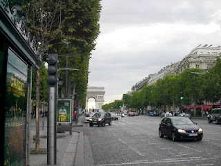
Paris - France

Dr. Edmar Bernardes DaSilva (Masters in Geography and Doctor of Geography Education)

Europe the so called Old Continent (even though the cultures are younger than Asian ones) still has a lot to learn from the newer continents like the Americas. Robb and I went to Western Europe for 18 days, and as a geographer I am more critical about the physical and human geography of the region than Robb is. Doing the Dusserdorf to Paris and back trip we saw great landscapes (cultural and natural), but we experiecend great deceptions too.

In Germany (Deutschland) the people are always running in big cities like Frankfurt. The Germans are some how friendly but still have 40-year old views about Brazil and even the USA. The weather plays a lot shaping Germans’ personalities which can be friendly but dark. The summer is not really summer in Germany, because some days it gets cold and wet like the winter in central and southern Florida. Bavaria is a dream land, a land that came out of brothers’ Grim fairy tales. Frankfurt is a big city like any other big city out there. As the financial center of Germany it gets a lot of national attention. The good thing about Frankfurt it has a historical past, a historical old city and a lot to do. Frankfurt is loaded with wonderful German beer gardens. In Germany I tasted the best beer in Europe. Munich is a great city that needs more time than we had to explore. The Bavarian Alps give Germany a unique Germanic southern landscape. The Rhine River valley is a fairy tale dream with castles and vinyeards. The food in Germany reminds me the country home made food from my home state in southeastern Brazil. Trains are great in Germany and France but the people taking them are rude and impolite. When the train arrives in the train depot everybody wants to get in and out at the same time. What a mess! Inside the train things get worse.

The Germans in my point of view are very Americanized: you don’t need to come to the USA to listen to American music, because German radios play it all the time. They still have a colonial view of the USA. They also have a wrong view of Brazil. They must learn that Brazil and the USA are very multi-racial and multi-cultural societies made up of immigrants.

Inside Paris - France

France on the other hand has great cultural and physical landscapes, but the people are rude and unfriendly with tourists. The Louvre, Champ Elysees, and the Eifel Tower are really great post cards from Paris. I found the French very nationalistic about their language and culture, a nationalism with a old fashion Latin attitude (French culture after all is a Latin based culture with French flavor). France is also a multi-cultural and multi-racial society, but its politicians want to make the citizens of France believe that French society is not a multi-cultural and multi-racial society. Paris is a great city but with a lot problems with traffic, too expensive and also loaded with immigrants from the sub-continent (India, Pakistan…) and Arabs from North Africa. In Paris we drank the most expensive water of our life. We paid around $20 American dollars for two small bottles of water (Avoid Le Carrousel near Les Tuileries at all costs! This place is a real rip off!) Strasbourg (Straßburg) on the other hand is better than Paris, because it is much smaller and people are nicer to tourists.

Over all, the trip to Western Europe was a great trip, but with its ups and downs, and deceptions. To use the phone in France to make an international call is almost impossible. Dusseldorf airport gave me one of the worst experiences I had in an international airport. But in the end the trip was a great experience and as a geographer I learned up close and personal that French and German citizens are somehow biased about the world out there.

The Rhine River and Valley - Germany

Copyright © All rights reserved 2010

A Little Bit of the Geography of Florida

Florida Highlands (The Central Florida Hills)

Dr. Edmar Bernardes DaSilva (Masters in Geography and Doctor of Geography Education)
Florida is a mostly flat state with some rolling hills in its central region and in its northern region bordering with Georgia. The three physical regions of Florida are: the Atlantic Coastal Plain, the East Gulf Coastal Plain, and the Florida Uplands. The Florida Uplands go from the northwest corner of the state, along the northern edge of the Florida Panhandle and then extend south into the central area of the Florida peninsula. Though the Florida highlands are only 200-300 feet above sea level, they are much higher than the lands of the Atlantic Coastal Plain and the Eastern Gulf Coastal Plain.

The State of Florida is 500 miles (800 km) long and 160 miles (256 km) wide at its most distant points. The state is bordered by Georgia and Alabama to the north. On the west Florida is bordered by Alabama and the Gulf of Mexico. To the south and to the east, Florida is surrounded by the Atlantic Ocean. Florida covers 65,758 square miles (105,213 square km), making it the 22nd largest of the 50 states. Florida’s 53,997 (86,395 square km) square miles are land areas, and 11,761 square miles (18,818 square km) of Florida are covered by water making Florida the 3rd wettest state after Alaska and Michigan. Florida’s highest point is Britton Hill, in northwest Florida in the border with Georgia in the Florida Panhandle, and is 345 feet (105 meters) above sea level. The highest point in the peninsular Florida is the Sugar Loaf, which stands 312 feet high (95 meters). Florida’s lowest point is the sea level where Florida meets the Atlantic Ocean and the Gulf of Mexico. The average land altitude in Florida is only 100 feet (30.48 meters) above sea level.

Florida’s major rivers: Saint Johns River, Saint Marys River (between Georgia and Northeastern Florida), and Suwannee River (Georgia and Florida).

Florida’s Major Lakes: Lake Okeechobee, and Lake George.

Florida also has a great number of canals.
Physical Map of Florida

Copyright © All rights reserved

Florida Central Highlands (a wonder inside Florida)


Dr. Edmar Bernardes DaSilva (Masters in Geography and Doctor of Geography Education)

When you are living in South Florida you might think that the entire state of Florida is flat, and with no highlands at all. Well this is not true, because this week I visited with a friend of mine to the Florida Central highlands region, which is a very nice hilly region in Central Florida where lakes and low hills shape the physical landscape in the Lake County region. When I arrived in the region searching for Sugarloaf Mountain, which is the highest point in peninsular state of Florida at 312 feet (95 meters) above the sea, I was surprised to see a highland region inside Florida.
Florida Hills (Central Florida)

Even though I am a geographer, I always had this preconception that the state of Florida is totally flat and without any kind of hills. I was wrong! So I learned that the highest point in peninsular Florida is located inside Lake County, not far from the city of Clermont. Clermont, by the way, is a charming, small town surrounded by lakes of different sizes (e.g. Lake Apopka). Britton Hill, in the Florida Panhandle, is the highest point in the entire state at 345 feet above sea level. That is not very high either!!!! The state of Florida should add a course on the Geography of Florida to the school curriculum (high school and junior college). Florida is a state with a great and interesting geography which most Floridians know very little of it.
Florida Hills (Central Florida near Orlando)

Copyright © All rights reserved

Social Sciences and Geography


Dr. Edmar Bernardes DaSilva (Masters in Geography and Doctor of Geography Education) 

The social sciences are a bunch of academic disciplines, which concerns the human aspects of the world and their connection with this same world. They are different from the arts and humanities because social sciences tend to emphasize the use of the scientific method when studying humanity, and when doing that they include quantitative and qualitative methods of study.
They refer to social sciences as SOFT SCIENCES because those sciences study the subjective, inter-subjective and objective structural aspects of society, whereas the natural sciences are referred to as HARD SCIENCES, which focus mostly on the objective aspects of nature.

This excepts geography, for example, in which one finds that this subject (geography) has very strong sides of both SOFT and HARD sciences. Geography can be considered a double identity discipline, which holds to both sides of the scientific world: human and natural. Before today the distinction among the hard and soft sciences was fuzzy, though nowadays some social science sub-fields have become very quantitative in their methodology. Examples of boundary subjects between soft and hard sciences are disciplines such as geography, sociology, history, sociobiology, bio-economics and the sociology of science (e.g. Thomas Kuhn). More and more quantitative and qualitative methods are being integrated in the study of human action and its implications and consequences (e.g. geography).

Social Sciences Disciplines:
Anthropology
Geography
History
Economics
Education
Law
Linguistics
Political Science
PsychologySociology...


Copyright © All rights reserved

Geography of the Environment

Lake in Florida

Dr. Edmar Bernardes DaSilva (Masters in Geography and Doctor of Geography Education) 

What is Environmental Geography? Well, think this way: Environmental Geography and Natural Resources help us comprehend human kind manipulation of the natural world and the use of its natural resources by those same humans. The study of Environmental Geography teaches us how humans impact and modify the environment, and as well teaches solutions that can be used to control resources in a way that human kind will have them for years and years to come. Environmental Geography also teaches about politics and policies, news studies on environment conservation, and important issues from global warming, water resources and land degradation. Finally Environmental Geography teaches us to understand how natural resources have become a critical issue in local, regional, federal and international land use actions.


When you concentrate your studies on Environmental Geography you learn:
A: How to analyze environmental and resource use and impacts
B: About the policies and programs that take place in governmental spheres addressing environmental issues
C: How to use accessible technologies to create and present data and Findings.

Physical Landscape in Mongolia

Pollution in China (Pic by the World by Road Expedition)

Copyright © All rights reserved

Human Geography

Folk Dance of Nepal

Dr. Edmar Bernardes DaSilva (Masters in Geography and Doctor of Geography Education) 

Human Geography is a branch of Geography that concentrates its attention on understanding the interaction between humans and the space they live in. Human Geography in reality concentrates on the prototypes and developments that mold the connection between the environment and humanity. In short Human Geography particularly takes care of the sources and effects of the spatial distribution of human activity on the Earth’s crust.

One of the notable human geographers is the German Karl Ritter, one of the founding fathers of modern geography together with Alexander von Humboldt, a German as well. Herr Doktor Ritter brought a new beginning to the subject of geography. Ritter was also a pedagogue who concentrated his pedagogical studies on geography teaching and learning. For Ritter the teaching of geography resembled the teaching of physiology and comparative anatomy of the earth: The Earth’s rivers, mountains, glaciers and more were so many distinct organs, each with its own appropriate functions; and, as such this physical frame is the basis of the man, determinative to a large extent of his life, so the structure of each country is a leading element in the historic progress of the nation.

Some of the sub-fields of Human Geography are: Cultural Geography, Economic Geography, Political Geography, Medical Geography, Urban Geography, Population Geography, Tourism Geography, Transportation Geography...
Ouro Preto Brazil - A Urban Cultural Landscape


Copyright © All rights reserved

Field of Geogarphy

Dr. Edmar Bernardes DaSilva (Masters in Geography and Doctor of Geography Education)
Cartography
Making, analyzing and understanding maps


Physical Geography
Physical Geography (or physiogeography) focuses on geography as an Earth Science. It aims to understand the physical LITHOSPHERE, HYDROSPHERE, ATMOSPHERE, PEDOSPHERE and GLOBAL FLORA AND FAUNA. Physical Geography can be divided into the following categories:

Biogeography, Climatology & Paleoclimatology, Coastal Geography, Geodsy, Geomorphology, Glaciology, Hydrology & Hydrography, Landscapes Ecology, Oceanography, Pedology, Paleogeography, and Quartenary ScienceHuman Geography
The Brazilian Highlands

Human Geography
Human Geography is a field of geography that focuses on the study of patterns and processes that shape human interaction with various environments. It encompasses human, cultural, political, cultural, social, and economic aspects. While the major focus of human geography is not the physical landscape of the Earth , it is hardly possible to discuss human geography without referring to the physical landscape on which human activities are being played out, and the geography of the enviromment is emerging as a link between HUMAN AND PHYSICAL GEOGRAPHES. Human geography can be divided into the categories below:

Cultural Geography, Development Geography, Economic Geography, Medical Geography, Historical Geography, Political Geography, Population Geography, Religion Geography, Social Geography, Transportation Geography, Tourism Geography, Language Geography and Urban Geography

Urban Geography of Savannah Georgia

Copyright © All rights reserved


Spatial Skills

Dr. Edmar Bernardes DaSilva (Masters in Geography and Doctor of Geography Education)

GIS Map of Part of Florida - Source: Florida Department of Environmental Protection

Competent citizens must be able to locate themselves and others SPATIALLY in order to travel, exchange ideas, and access artifacts. SPATIAL SKILLS often appear in social studies in the discipline of GEOGRAPHY, but they are all over throughout the curriculum.
Identifying political boundaries, the locations of cities, landmarks, and landmasses and determining the relationship of one object in space to another are all part of SPATIAL UNDERSTANDING.

Using and Creating Maps in Instruction

The most common ways that individuals can orient themselves SPATIALLY are through exiting MAPS and the creation of new ones.
MAPS (e.g. flat maps) and GLOBES represent some region on the Earth.
They do so with varying degree of distortion. Globes are more accurate.

In 1988 the National Geographic Society adopted the Robinson Projection as one that produced the LEAST DISTORTION for most non-specialized map applications.
If compared with the traditional Van der Grinten Projection that the society used since 1922, one can see that there is less distortion.

Satellite Map of Florida (Source: National Oceanic and Atmospheric Administration)

Copyright © All rights reserved